Codes
Pyticles
Pyticles is a Python/Fortran hybrid parallelized code for Lagrangian particles 3D advection from high-resolution ocean models data. The code has been used in [5], [6], [7], [8], and [9].
The code is available on GitHub
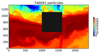
Example of tracking particles backward and forward.

| [5] | J. Gula, J. Molemaker and J.C. McWilliams (2014)
Submesoscale cold filaments in the Gulf Stream.
J. Phys. Oceanogr., 44(10), p2617-2643.
|

| [6] | C. Vic, G. Roullet, X. Carton, X. Capet, M.J. Molemaker & J. Gula (2015)
Eddy-topography interactions and the fate of the Persian Gulf Outflow
J. Geophys. Res., 120, doi:10.1002/2015JC011033.
|

| [7] | J. Gula, M.J. Molemaker & J.C. McWilliams (2016)
Submesoscale dynamics of a Gulf Stream frontal eddy in the South Atlantic Bight.
J. Phys. Oceanogr., 46, 305-325.
|
| [8] | J.M. Klymak, R.K. Shearman, J. Gula, C.M. Lee, E.A. D’Asaro, L. Thomas, R. Harcourt, A. Shcherbina, M.A. Sundermeyer, M.J. Molemaker and J.C. McWilliams (2016)
Submesoscale streamers exchange water on the North Wall of the Gulf Stream
Geophys. Res. Lett., 43, 1226–1233.
|

| [9] | J. Gula, J. Molemaker and J.C. McWilliams
Submesoscale instabilities on the Gulf Stream North Wall
J. Phys. Oceanogr., In Preparation
|
WRF-FLake
The Weather Research and Forecasting (WRF) model has been coupled with the Freshwater Lake (FLake) model. The offline methodology has been tested and used in [1]. The fully coupled WRF-Flake model has been used in [2], [3], and [4].
The FLake routines can be automatically included in the WRF code by running an update script. The script and adapted Flake routines are available for WRF versions 3.4.1, 3.5, 3.6 and 3.6.1.
Download: [WRFFLakeV3.4.1, WRFFLakeV3.5, and WRFFLakeV3.6/3.6.1. ]
Lake depth data to be used with WPS, adapted from the Global Lake Database, are available here. Starting from version 3.6 these data have been included in the default WPS Geographical Input Data Downloads.
Please let me know when you download the codes (gula [ at ] ucla [ dot ] edu) and reference [1] and [2] if they are used in your study.

| [1] | (1, 2) J. Gula and W.R. Peltier (2012)
Dynamical Downscaling over the Great Lakes Basin of North America using the WRF Regional Climate Model:The impact of the Great Lakes system on regional greenhouse warming.
J. Climate. 25, p7723-7742.
|

| [2] | (1, 2) M.S. Mallard, C.G. Nolte, O.R. Bullock, T.L. Spero and J. Gula (2014)
Using a Coupled Lake Model with WRF for Dynamical Downscaling.
JGR Atmospheres, 119, p7193-7208.
|

| [3] | M. d'Orgeville, W.R. Peltier, A. Erler and J. Gula (2014)
Climate Change Impacts on Great Lakes Basin Precipitation Extremes.
JGR Atmospheres, 119, p 10799-10812.
|

| [4] | M.S. Mallard, C.G. Nolte, T.L. Spero, O.R. Bullock, K. Alapaty, J. Herwehe, J. Gula ** and J. Bowden** (2015)
Technical Challenges and Solutions in Representing Lakes when Using WRF in Downscaling Applications
Geoscientific Model Development, 8, 1085-1096.
|